Tuesday, 11 July 2017

Two Days R&R in Regina

After driving around 2600 km in 5 days, we took a couple of days off in Regina to visit Brian’s brother and sister-in-law, Dave and Val.

You couldn’t have pictured different weather than what we had experienced in Ontario.  Both days were sunny, with highs of 31C and 34C.

On Sunday, Dave and Val took us for a walk along Regina Beach, about a 45-minute drive north of Regina.  There really was a big lake!  And lovely sandy beaches.  And the place was hopping with visitors.


Apparently, the iconic place was the Blue Bird CafĂ© which sold fish and chips.  Of course we had to stop and partake.


The next day, while Dave and Val worked, we rode our bikes around Wascana Lake, a beautiful parkland in the south-central section of Regina, near the university.  


There were a number of major sights, like the Regina Parliament Building (reminding me very much of that in Edmonton) and the Queen’s gardens.


Canadian geese were all over the place, and we got to see some youngsters in flight training, running along the ground flapping their wings, and almost (but not quite) getting airborne.


When it is 344C and you are cycling, Wascana Park becomes a bit of a cyclist's dream, because they have sprinklers everywhere.  We thought that was wonderful, but the poor gal in the picture shrieked every time one hit her.


Now I have to explain a bit of what is normal in Western Canada.  After a good crop of tent caterpillars, you are going to get the moths.


And you can get lots of them.


Sunday, 9 July 2017

Kenora to Regina

Lots of time was spent in the car today, for we did about 800 km.  As we left Kenora we travelled up and down through twisty bits at 90 km per hour on a two lane road until we reached Manitoba.  Ten kilometers later, the land started flattening, the road expanded into a big 4 lane divided highway, and the speed limit went to 110 km per hour.  Gas prices dropped from 111.9 per liter to 86.9 per liter.  We were in the prairies!

It was amazing how the land flattened out so quickly, and I was thrilled to find canola fields in bloom.  When the sun shines on a field it almost glows with the colour.  What I didn’t expect were flax fields in bloom, looking almost like a field of blue water—beautiful.  The fields were bigger, 50-100 acres in size, and had some lines of trees between them.

I can’t say there were a lot of pictures today (note to self—put high speed camera on front of car).  (Note to self—put big bug screen on camera).  We did stop at a tiny little diner in beautiful downtown Austin Manitoba (population 442) and it turned out to have excellent food and service.


As we travelled through the day, the wildflowers in the ditch changed to yellow sweet clover and a different variety of vetch.  When I went out of the car to take a picture, the sweet fragrance was overwhelming.


Trees have changed so that poplars are now predominant, and the further west we get the shorter the trees.

I continue my thesis that the further west explorers got, the less imagination they had for road names.  Manitoba featured Road 21 West, followed by Road 22 West, followed by Road 23 West……you get the picture.  Apparently someone stopped and found firewater, for they waxed lyrical and named ……. Squirrel River!  And Bison Road!  That giddiness passed quickly and we were now at Road 40 West, etc etc.

Instead of car dealerships in small towns, they have farm equipment dealerships.  The inventory must cost millions, for there are a lot of BIG machines.

As we progressed into Saskatchewan, the road names merely changed to that of Range Road #2203, Range Road #2204………  However, to pass time during the last part of the long haul, I started measuring the length of fields along the highway.  To summarize, short fields were only .5 km long, but most of them were .9 to 1.2 km long.  No trees.   Sometimes a road intersected the highway, but it was inevitably gravel, and any vehicle on it would leave a long line of dust far after it had passed.

Here is a picture of a common Saskatchewan field.


Here is a picture of a common Saskatchewan highway.  (If there are any deviations from absolutely straight, they put up curve markers to warn you.)


And here is how you forecast weather in Saskatchewan.  We could see this cloud 80 km off before we ran into a little bit of precipitation from it.


Days are long here--the sun rises about 5 am and sets around 9 pm.  This takes a little acclimatization because it is still light when we are ready for bed, and we can't figure out what is wrong.


Brian’s brother and sister-in-law live in Regina, so we will spend a couple of days here before getting back in the saddles.

Thunder Bay to Kenora

I will show you a picture of the most prevalent part of the day.


Yes, this is a rock face.  This is a rock face that has been drilled and blasted to allow for a road.

This is a highlight.

Shall we say that today was a bit boring?  We did 500 km, from Thunder Bay to Kenora, and 400 km of that was through Boreal Forest.  The roads were flat, the trees were short, and the wildflowers were the same.  I did note two differences:  some larch trees appeared, and there was more lichen than grass on the bare patches.  Whoopdedoo…….

Warning signs for large mammals on the road went from deer to moose to deer to moose, etc, etc.  Moose dangers were more prevalent.

In looking for unique road names, I have come to the conclusion that explorers were bored out of their minds when they got west to this point.  Lone Pine Road.  Spruce Road.  Poplar Beach Drive.  Red River, Black River.  Sandy Beach Cove.  Beaver Creek.  Current River.  (Did that mean there was a Past River?) 

There was less road construction today, but what little there was made up for it.  We passed one light-regulated single lane road and one short flagged stretch, and did extremely well until late in the afternoon.  Then we came to a 5 km stretch of total road replacement, with a single lane of traffic.  When the flag person parked the stop sign in an orange and black striped traffic cone, I knew we were in trouble.  Then they started moving traffic cones.  Minutes later, a stream of over 80 vehicles passed through, followed by a water truck and a follow-me vehicle.  This allowed ample time to take pictures of rocks, paving vehicles, and generally nothing in particular.


After all these negative thoughts, as usual we had a highlight to make the day memorable.

Brian’s kayak is named the Noble George II, based on an old scout camp boat used to row to an overnight camp near Lake of the Woods (the area we were in tonight).  This adventure was a highlight for him because he was in his early teens living in Gimli, and the old boat was named the Noble George.  When Brian got his prized kayak, it was natural for him to name it the Noble George II.


We had stopped for the day at a little motel, and went out for a modest dinner at another motel’s restaurant.  As we left after our meal, a fellow who went outside to smoke a cigarette admired Brian’s kayak, and started making comments about boats, etc.  He was a local, and told Brian about the story of another local fellow called George Noble, who loved kids and boats and spent innumerable hours supporting kids at camps.  Brian almost got shivers at this, because it was obvious how the Noble George got its name.  The two men had a lovely conversation and Brian said it felt almost preordained that he would find a story like this about something that was so special to him.

Thursday, 6 July 2017

Wawa to Thunder Bay

If you ever have some time for sightseeing, I really would advise driving over the north of Lake Superior.  The scenery continues to be spectacular.

We had another day of fine weather, and less road construction (I think).  After all, we only went through 5 flagged stops and two one-lane sections controlled by traffic lights.  Road construction here is not trivial, given that it involves blasting through great depths of hard rock.  The importance of Highway 17 and the cross-Canada trucking means that roads get a lot of heavy use.  

We learned a new game called truck-tag today.  There are a fair number of passing lanes every 12-15 km to give faster traffic a chance to overcome those of us doing the speed limit. I have learned, however, that the passing lanes are inevitably on the up hill portion of the road, leaving trucks to the disadvantage.  However, when you start dropping on the 6-7% declines, Mr. Truck (who has only done this route several hundred times) is breathing up your tailpipe.  Generally, the truckers are the smart folks on the road, compared to the beamers, pick-up trucks and sports cars who feel the need for speed, especially when confronted with oncoming traffic.

When I say the scenery was spectacular, it was the small stuff that really caught the eye. Roadsides featured abundant wildflowers coloured orange, yellow, white and purple.


And even of greater surprise were patches of.....


Lupens!  I saw a few at first and dismissed them as erratics, but then we came upon patch after patch in the afternoon.  They didn't seem widespread, but every now and then you would come upon a ditch full of them.  I don't know what prompted them to grow in such spots, but they were in full bloom and beautiful.

The trees have changed as we have moved from east to west.  Black spruce has become prevalent, and the forests are not as tall.  In the eastern part, poplar was more prevalent, although many patches looked like they were just coming into spring.  I suspect an explosion of tent caterpillars because many trees were completely exfoliated.  

We have had a couple of great wildlife sightings today, including that of a wolf crossing the highway directly in front of Brian's car (a very healthy looking wolf) to what I suspect was a young wapiti (elk) grazing in a ditch outside of Thunder Bay.

We have seen and met a number of intrepid road warriors.  We saw about a dozen touring cyclists today, comprising about 75 % men, with a big number of them sporting our hair colour.  (Wow!)  The big touring motorcycles again comprised about 75% men, and about 75% sporting our hair colour.  Apparently we are the ones with time and money to do these things.

We cycled around Lake Superior in 1990, and I marvel now at what we did.  As car gas tank ranges get longer and longer, all the smaller stops along the way have closed down.  For much of the day, the Transcanada was only two lanes going up and down over long hills and drops.

Before I bore you to tears with nostalgia, I have to mention the minor excitement in the afternoon.  Severe thunderstorm warnings had been posted in the afternoon, and we ran into a really nasty little hail cell that forced us off the road.  Bean-sized hail pelted us for about 5 minutes, causing Brian to twitch every time one hit his new car.  

The picture isn't great, but it does give the suggestion....


Near the end of the day, we stopped at the Terry Fox statue, which we have now seen two times.  In 1990, it was merely at the side of the two lane highway, and just featured the statue.  Today, there is now a monument which has been moved into a park to overlook a four lane divided highway.


Given the roads and hills we have covered for days now, the statue is so evocative of the effort Terry Fox made and a tribute to how he has changed the perceptions of Canadians.  

After 500 km on the road today, we ended up at a hotel outside of town with a beautiful view in its ample backyard.


Life is good.


Wednesday, 5 July 2017

Georgian Bay and Lake Superior Views

Day 2 on the road is complete, and we are finally back in the land of WIFI.

Yesterday, we travelled from Coldwater to beautiful downtown Spanish ON.  Where?  Well, it is just down the road from Espanola.  All I can say it is 378 km from Coldwater, but it featured a beautiful cabin for two, and some marvellous views of the North Shore of Georgian Bay.

First the cabin.  It is rather ironic that we left a log home and ended up staying in a log cabin overnight.


The place was delightful and petite, with everything required.  Now that I think about it, perhaps this is the right size of downsizing!

The hostess is an artist, and the cabin featured her acrylic work while she did her oil painting in her home.  The walls were peppered with what she called "Primitive Art", which apparently sells well.  She said she was willing to paint anything, and we saw everything from an oxen yoke to sawblades, driftwood and rocks embellished with colourful scenes.

Spanish has a population of about 700 people, and is on the north shore of Georgian Bay.


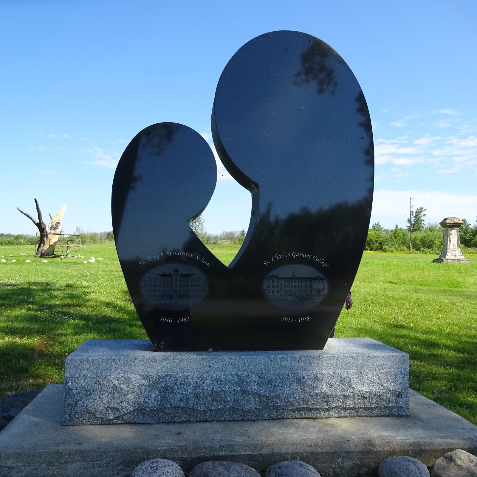
It apparently is famous for its residential schools--the boy's one has been torn down, but the girl's one is left standing as a monument (by its private owner) for the time.


At a local park, there is an attractive monument (real one) to the time.


When you stop to see these things, the depth of history always amazes me.  Apparently prisoners of war were housed at one time in Spanish as well (were they in residential schools, or should I ask?)

Once we left Spanish, and travelled to Sault St. Marie, we embarked on a beautiful set of dramatic hills and valleys around the north shore of Lake Superior.   The hills are rounded mounds of glaciated granite, with little in the way of flat stretches for 200 km.


If you do see shoreline of the lake, it is generally rocky, although there were some very sandy areas.

Highway 17, the main road over the northern part of the lake is merely two lanes, and the trucking traffic is huge.  Our drive was fine, but I do remember the saying that Canada has only two seasons:  (1) is winter, followed by the (2) road construction.  We went through numerous areas of road work, with three main ones featuring flag people.  The shortest was about a 5 minute wait; the longest was about a 20-25 minute wait (a passerby told us that they had counted up to 220 vehicles waiting to go in one direction).  Having said that, the drive over the top of Lake Superior is truly gorgeous.

We have landed in beautiful downtown Wawa tonight (3700 people) and bagged one of the last hotel rooms in the town.  Planning ahead for summer travel might be greater in the future!

Tuesday, 4 July 2017

The Homeless are on the Road

After a morning of errands, repacking, and oil changes, we are now officially on the road.

The sale of the house went cleanly last week, and we are now "homeless".  Thus, let me introduce you to our two new mobile homes.

Brian's


And mine....


Let the adventure begin!

Thursday, 29 June 2017

The storm before the lull--we are now homeless

If we have ignored any of you this week, we apologize.  The packers were in Monday and packed up all of our telephone and internet gear.  It took three ladies almost 2 days to pack everything (and we thought we had downsized!).


The movers were in Tuesday and everything was eventually placed in a semi-trailer (and we thought we had downsized!.....) to make its way out to BC.

In the meantime, the breezeway has become the Do Not Pack area, and all of this stuff should fit into two cars (right).  (Apparently we have NOT downsized...)


The house has been completely cleaned, and locked up tonight for the new owners.

In the meantime, just call us the Malloy Turtles (well, it's kind of like having everything on our back).

We start driving Tuesday morning, to miss the long weekend traffic, and will stop wherever our fancy takes us along the way.  Internet availability permitting, I will start sending updates next week.  Consider the malloysathome.blogspot.ca the sign of a new approach to having home wherever we are!